Cyclists in Cape Town Map a Route Through the Physical Legacy of Apartheid
Zero Signal Staff
Published May 5, 2026 at 7:01 AM ET · 70 days ago
The New York Times
Cape Town's apartheid-era divisions are not confined to history books. They are written into the streets, buffer zones, and undeveloped corridors that still separate neighborhoods today.
Cape Town's apartheid-era divisions are not confined to history books. They are written into the streets, buffer zones, and undeveloped corridors that still separate neighborhoods today. A recent feature in The New York Times traced a bike ride through one of those corridors, following cyclists who treat the route as a living map of lingering segregation. The ride illustrates what urban researchers have long documented: that the city's physical layout remains a product of policies designed to divide, and that the space between communities can be as telling as the communities themselves. For the cyclists involved, the journey is not simply exercise. It is a way of reading the city that surrounds them, tracing paths that were carved by law rather than convenience.
The Details
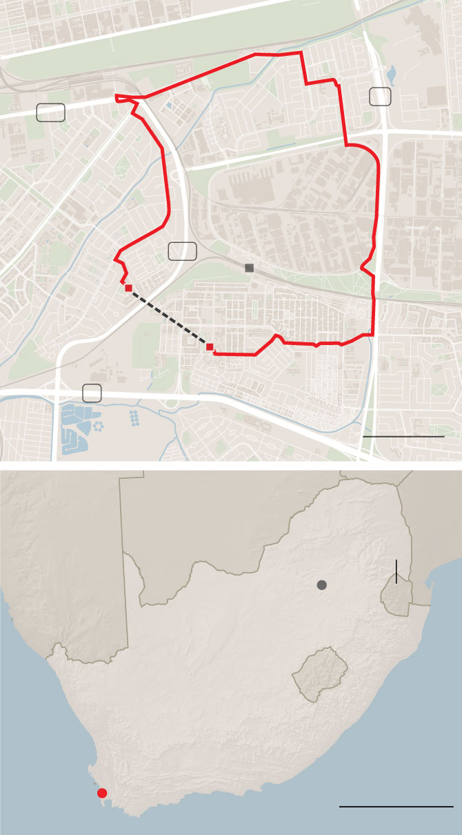
The feature, published on May 5, followed a reporter who joined members of Young Urbanists, a South African advocacy group focused on urban planning, mobility, and safer streets. According to indexed excerpts of the article and supporting material from the organization, participants pedaled through an undeveloped buffer zone that was deliberately kept open during apartheid to separate predominantly Black and Coloured communities. The buffer sits between Bonteheuwel and Langa, two neighborhoods whose separation was shaped by forced-removal policies and spatial planning designed to enforce racial segregation. A University of Cape Town architecture thesis specifically identifies this corridor as an example of how apartheid-era infrastructure was used to isolate neighborhoods from one another. The route was not selected for scenery. It was chosen because the empty land still functions as a physical barrier decades after the laws that created it were repealed. Young Urbanists organizes public events around safer streets, cycling, and urban integration, using rides as a means to make the abstract geography of segregation tangible and visible to participants and observers. When the group wrote about a similar Cape Town cycling tour in March 2023, they argued that transport fragility persists because successive governments failed to undo apartheid spatial planning and because walking and cycling remain unsafe across much of the city.
Context
The bike ride draws on a well-documented history of spatial engineering. The Group Areas Act, as summarized by historical records, empowered South African authorities to designate neighborhoods for specific racial groups and forcibly remove residents who did not match the prescribed classification. The law became a primary tool for creating the segregated urban geography that still defines Cape Town. A research project hosted by the University of Cape Town describes the post-apartheid city as fractured, with infrastructure and large open spaces used deliberately to keep neighborhoods isolated. The thesis specifically identifies the buffer zone between Bonteheuwel and Langa as one such example of how physical design enforced social separation. Beyond the local case, a peer-reviewed historical overview published in the Journal for Transdisciplinary Research confirms that colonial and apartheid-era policies produced long-lasting spatial injustice and segregated settlement patterns that continue to characterize South African cities today. The scholars argue that these patterns were not accidental byproducts of urban growth but intentional instruments of control, and that the physical evidence of this engineering persists in the layout of roads, open spaces, and settlement boundaries across the country. For residents of Bonteheuwel and Langa, that evidence is visible every day in the undeveloped land that still divides them.
What's Next
Young Urbanists has been making similar arguments for years, framing safe active mobility as both a practical need and a form of restorative urban policy. In a March 2023 essay, the group argued that Cape Town's transport fragility persists because successive governments failed to undo apartheid spatial planning and because walking and cycling remain unsafe across much of the city. The organization frames these rides partly as education and partly as a demand: that safe streets for pedestrians and cyclists could be a step toward reversing the legacy of forced separation. In coverage of their work, Roland Postma put it this starkly: "If every neighbourhood is safe for our children to walk and cycle we will have transformed our cities and towns, and addressed apartheid spatial planning and the car-centric sprawls, malls and estates." The New York Times feature adds national and international visibility to a point the group has long pressed locally. Whether that visibility translates into faster policy change remains an open question. What is clear, however, is that the buffer zone between Bonteheuwel and Langa remains undeveloped, and the ride through it serves as a reminder that some maps change more slowly than laws.
Never Miss a Signal
Get the latest breaking news and daily briefings from Zero Signal News directly to your inbox.